Key (Basics)
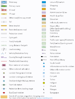
Maps have keys. Just like a key to a door, the key on a map helps you to unlock the information stored in the colours and symbols on a map. You must understand how the key relates to the map before you can unlock the information it contains. The objects on a map are represented using symbols. A symbol is a picture on the map that represents something in the real world. To understand the symbols on a map you need a key. The key will help you to identify types of boundaries, roads, buildings, agriculture, industry, places of interest and geographical features. The key usually shows a small picture of each of the symbols used on the map, along with a written description of the meaning of each symbol.A good example of a map key is shown below:
I have seen a very good year 7/8 Geography lesson where pupils were encouraged to guess the different symbols on a PowerPoint where the answer is then revealed. This would then lead to pupils making up their own symbols for objects that already exist or don't yet exist. They would then place these on their own made up map with their own key. A good plenary would be that the class have to guess each others key symbols whilst being shown at the front.
I found this interesting lesson planned and resourced. It could used for ideas or adapted for your own use.
http://www.ngfl-cymru.org.uk/vtc/map_symbols_keys/eng/Introduction/default.htm
Simple and straight forward but with some helpful resources and ideas.

this is literlly my homework.lol
ReplyDelete